Mao river walkways and Mao River Canyon route
The route walkways from the Mao River to the Sil Canyon is one of the more beautiful and affordable Ribeira Sacra (and also one of the most unknown parts what to visit in Galicia). In this article I will explain with words, data and images how it is the experience of touring the canyon of the Mao River before flowing into the Sil. I will also talk about others hiking and mountain biking trails nearbys, like the Mao River Canyon route (PR-G 177), 16 Km and the route of a Teixeira (PR-G 224), 13.7 Km.
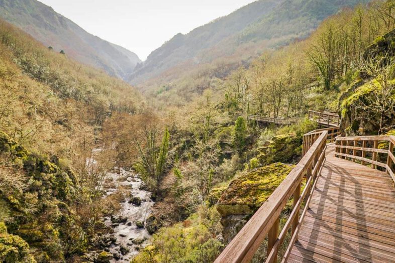
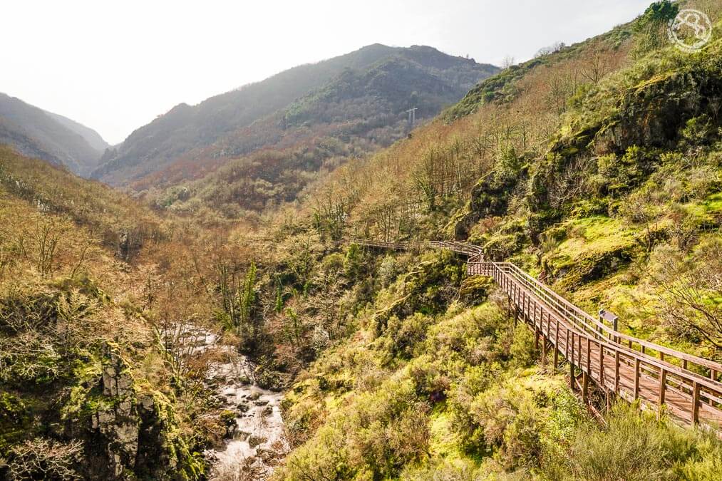
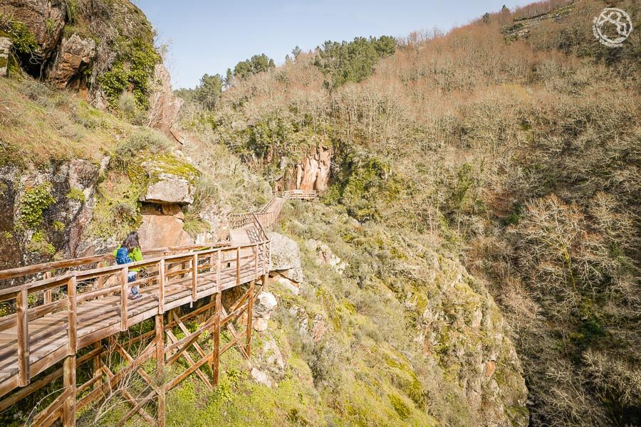
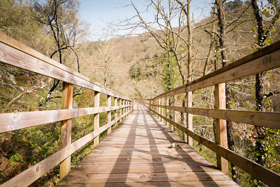
 Viewpoint of the catwalks of the Mao River, in the Mao Canyon
River walkways Mao and Mao River Canyon tour
I already advanced in this article about everything to see in the Ribeira Sacra and the canyons of the Sil that in this area there are multiple hiking trails. One of the most famous and affordable is the Mao river walkways route, which is part, in turn, of the PR-G 177, known as the Mao River Canyon route.
This article will focus on the catwalks of the Mao, but I will also provide information on other long routes that can be traveled in the area.
Mao river walkways route
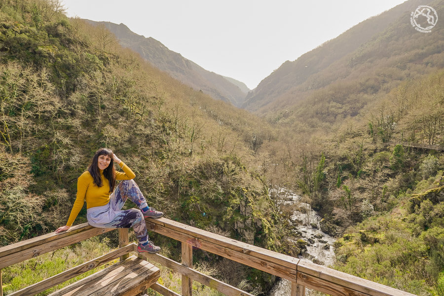
The Mao river walkways route is actually called the Mao River Walkway nature Circuit. It is a fairly affordable route both in hardness and extension. The total distance of the walkways of the Mao is 1.8 kilometers and the unevenness to be overcome (by stairs) is 41 meters.
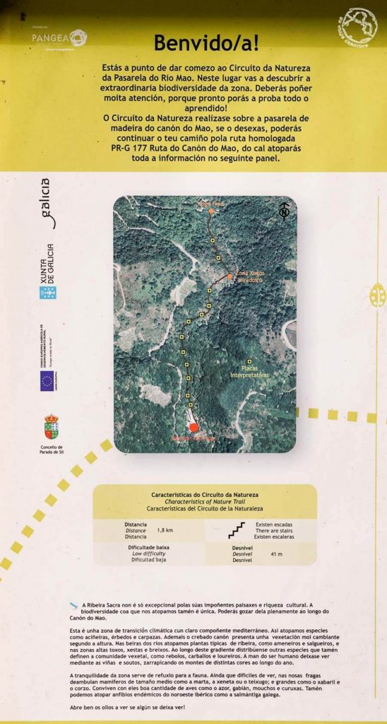
The tour begins at the Fábrica de la Luz, an old hydroelectric power plant converted into a hostel. This is, in turn, the starting point of the route of the canyon of the Mao River PR-G 177.
Next to the hostel there are several explanatory panels with the hiking routes (I will talk about them later) and BTT of the area, as well as the route of the catwalks of the Mao.
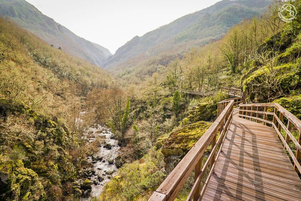
The route continues parallel to the course of the Mao river until its mouth in the Sil. While walking, we enter different points of the Forest, gaining height at times, which allows beautiful panoramic views of the environment.
Along the way there are different panels explaining the fauna, flora and geology of the area, as well as human activities (such as terraced farming and heroic viticulture, so characteristic of the Ribeira Sacra).
If you read these posters (which I recommend), you can discover that this is an area of climatic transition, with quite a Mediterranean component (we can find holm oaks or strawberry trees). However, the canyon of the Mao River has a very changing vegetation depending on the height at which we are. In low areas, near the river, there are Alders and willows, while in higher areas, the vegetation changes from chestnuts and laurels to Brooms, Heather or gorse.
One of the highlights of the route is the viewpoint located in the final third of the route, from which you can enjoy a privileged view of the Mao Canyon.
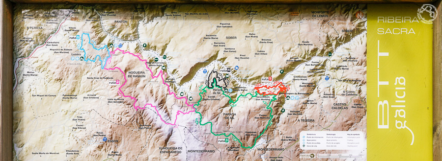 MTB routes in the Ribeira Sacra
Mao River Canyon Route (PR-G 177)
For those looking for a more ambitious hiking route, De La Fábrica de la Luz also comes out the so-called Mao River Canyon Route (PR-G 177).
This is a circular route of 16 kilometers and a slope of 990 meters (you ascend to the top of the canyon area). During the route you will pass through several points of interest such as the medieval necropolis of San Lourenzo De Barxacova, various panoramic viewpoints of the Mao Canyon and the towns of Forcas, a Miranda and San Lorenzo. From San Lorenzo you can continue to descend towards the canyon and link with the catwalks of the Mao or return where you climbed.
To see the interactive map, the profile of the route or, directly, download it, click this link of Tourism of Ribeira Sacra.
Route to Teixeira (PR-G 224)
Another route near the catwalks of the Mao River is the route of a Teixeira or PR-G 224. This is also another circular route, somewhat shorter than the previous one (13.7 kilometers) and with a similar slope (984 meters).
Officially, this route begins in the village of a Teixeira and, halfway, there is a path that descends to the Mao River. Arriving almost to the water level, crossing a bridge, you can connect with the walkways (then you would have to retrace the walkways, return and continue the circular route). There is also the possibility of making the path of the footbridges and, once reached the final third of these, cross the stone bridge to connect with the PR-G 224.
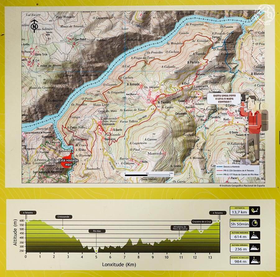
To see the interactive map, the profile of the route or, directly, download it, click this link of Tourism of Ribeira Sacra.
Where to sleep in Ribeira Sacra?
There are several options accommodation in Ribeira Sacra, as you want to be with a greater or lesser degree of comfort.
Campsites in Ribeira Sacra
In the area there is only one campsite, the Campings in Cañón do Sil, second-rate, near Sil stop. The place has both bungalows and space for tents and motorhomes. It has a bar-restaurant and the facilities are very well maintained. The best, its location, in the middle of the canyon and a few meters from the mirador de a mirada máxica and the good vibes transmitted by the couple who run the campsite.
Apartments and cottages La Ribeira Sacra
In Parada de Sil there are some interesting accommodations, such as
Paradores and pazos in the Ribeira Sacra
For those looking for more luxurious options:
To see all the accommodation options in Ribeira Sacra, click here or look at this map (sometimes not visible from your mobile):
Booking.com
More items from Galicia
Apart from the Mao river walkways route and the canyon of the Mao river, you can also read these other articles about Galicia and the Ribeira Sacra.
What to see in Ribeira Sacra: map and routes
Viewpoints of the Ribeira Sacra: map and locations
Catamaran through the canyons of the Sil: jetties, schedules, prices
What to visit in Galicia: 50 photos and 99 places
Visit Cíes Islands by land, sea and air
Route along the Costa da Morte by car: map, stages, secrets
Circular route through the province of Ourense, the great unknown of Galicia.
Things to see in and around Allariz
What to see in Ribadeo
Virtual gallery of the Meninas of Canido in Ferrol
What to see in Vigo, the city that will surprise you.
Serra do Xurés Natural Park, what to see and routes